Not a lot of iPhone users may know that their phone includes an animated map that can show incoming rain and other weather conditions. This can turn their device into an up-to-date barometer for incoming inclement weather. Apple's Weather app is one of the many built-in apps that have benefited from useful upgrades thanks to the iOS 15 update.
The iPhone's Weather app has gone through a significant design revamp that showcases important weather data more efficiently by dividing it into easily digestible sections. Cards for hourly and 10-day forecasts clearly show users what kind of weather conditions and temperature ranges to expect in the near future. There are also cards for air quality, the temperature at the user's location, UV index, humidity, visibility, and the chance of rainfall, to name a few. While all this neatly packaged weather information should be enough for most iPhone users to plan their day, the Weather app has additional features that are hidden in plain sight.
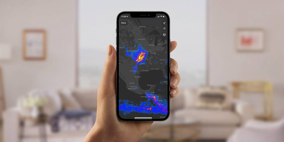
Apart from being able to enable the Weather app's notifications for incoming rain, hail, sleet, or snow, iPhone users can access real-time weather conditions through a map with an interactive layer that animates rain forecasts as they move through the area. To view the map, make sure the latest iOS version is installed on the iPhone. Launch the Weather app and tap the map icon on the lower-left corner of the screen. Tap on the square-stack icon located at the top-right corner of the screen and choose the Precipitation or rainfall layer.
View Interactive Weather Maps

Looping playback of the 12-hour forecast with the user's current location in the center will show cloud movements within the map section onscreen, enabling users to plan travel more appropriately. Users can touch the screen and drag a finger to move the map as well as pinch the screen to zoom in and out for a larger view of surrounding areas. In some countries or regions, people can zoom in on their location on the map to see the precipitation forecast for the next hour. The playback can be paused at the bottom of the screen so users can move the slider in either direction to see the weather changes in slow motion. This feature allows users to pinpoint exactly when and where rainfall is expected.
The Weather app has two other map layers that are just as useful. Temperature is the map's default view and shows where people can expect warm or cool climates. Air Quality color codes the entire map according to the U.S.'s official air quality index. Air Quality data is only available for Canada, mainland China, France, Germany, India, Italy, Japan, Mexico, Netherlands, Singapore, South Korea, Spain, the U.K., and the U.S. All three map layers are equipped with a handy color bar chart on the top-left corner of the page to understand what the hues depicted on the map mean for the layer selected. Two other buttons can be tapped on the top-right corner of the page. The arrow icon returns the user's current location to the middle of the screen. The list icon will show all locations defined in the user's weather list and their corresponding real-time stats, depending on what map layer is currently selected. Tapping on a location in the list will place it in the middle of the map screen. Hit Done to exit the map and return to the main forecast page.
It is important to note that the Weather app only shows weather predictions, most of them presented by The Weather Channel. These forecasts are not completely accurate and may be subject to change. iPhone users can go to their device's Settings, tap Privacy, select Location Services, and go to Weather to turn on Precise Location to increase the accuracy of the forecast in their current location.
Source: Apple