Following Russia's invasion of Ukraine and misinformation flooding in from all corners of the internet, a crowdsourced map that's available online attempts to provide reliable information about the situation on the ground. With ground-based reports of civilian and military casualties, the reliability of the information coming in is of the utmost importance.
A concern is that targeting network infrastructure will essentially leave the most vulnerable areas blind to the world. In such scenarios, there is a high likelihood that parties with vested interests can seed wrong information. False alarms also have the potential to make things worse for any civilians in militarized areas. However, reliable crowdsourced information may be able to help in some of these situations.
The objective of the Russia-Ukraine Monitor Map is to provide verified information to journalists, policy-makers across the globe, and anyone keeping track of the situation. The map was created by the Centre For Information Resilience, a non-profit that works to identify and counter the spread of misinformation, especially misleading propaganda from influential outlets and state-sponsored sources. The crowdsourced map aims to provides information with utmost transparency.
The Latest Updates On What's Happening

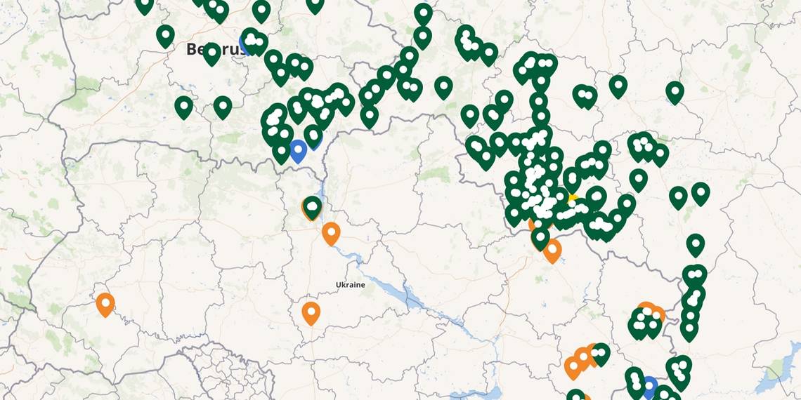
For those trying to keep up with what's happening, the map relies on colored markers to convey important information. Green depicts areas with heavy military presence, with active movement of troops as well as assets. Areas that are marked with blue are for checking satellite imagery of military activities. However, orange is used for areas that are currently at the center of rocket bombings, shelling, confrontation between armed personnel, and destruction of property. There’s a pane on the left that shows a detailed geographical record of military movements in January as well as February. Sitting below is a dropdown option for “Footage of bombing, shelling, explosion, or destruction” that opens up an exhaustive list of all the locations where incidents have been recorded, complete with date, geographical coordinates, and a brief overview of the activity. There is also the option to choose between various map formats such as street view, outdoor mode, and more. In addition to a helpful filter to quickly search for specific on-ground markets in affected regions.
Tapping on any pointer in the map opens an information window with all the necessary geolocation details, the ongoing turn of events, and the latest Tweets from verified sources to provide an accurate view of the ongoing situation. The official Twitter handle of the Centre for Information Resilience (@Cen4infoRes) is also actively fact-checking misleading content, including doctored videos and photos, as well as claims by sources. This is in addition to sharing up-to-date pictures and videos uploaded to the internet to help accurately depict what’s happening, while updating the map's database.
Source: Russia-Ukraine Monitor Map